Gettin' Here
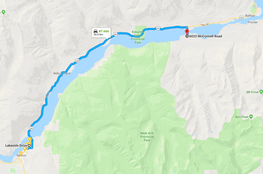
Nelson to Harrop Hall = 25 minute drive and 10 min ferry
Google maps directions
Head out of Nelson across the big orange bridge onto Hwy 3A. Drive 28km down the lake towards Balfour and Kaslo and take a right on Harrop Ferry Road. Please try to park on Harrop Ferry Road as there is not much parking at Harrop Hall and its only a 5 minute walk from the other side of the ferry to Harrop Hall just right on McConnell Rd after the train tracks.
Head out of Nelson across the big orange bridge onto Hwy 3A. Drive 28km down the lake towards Balfour and Kaslo and take a right on Harrop Ferry Road. Please try to park on Harrop Ferry Road as there is not much parking at Harrop Hall and its only a 5 minute walk from the other side of the ferry to Harrop Hall just right on McConnell Rd after the train tracks.
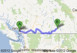
Vancouver to Nelson = 7-8hrs
Google maps directions
Head out of Vancouver onto the Trans Canada Highway via the BC-1 E ramp heading east and continue onto BC-3 E. After Hope take exit 177 for Crowsnest Highway/BC-3 E toward Princeton/Penticton. Take the 2nd right to stay on Crowsnest Hwy/BC-3 E (signs for Crowsnest Highway/Cawston/
Nighthawk USA/Osoyoos) In Osoyoos turn right onto Crowsnest Hwy/Main St/BC-3 E (signs for Grand Forks) and continue to follow Crowsnest Hwy/BC-3 E. When you hit Castlegar take the BC-3A exit toward Nelson
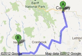
Calgary to Nelson = 6.5-7.5hrs
Google maps directions
Head south out of cowtown on Alberta 2 S. At Nanton turn right onto AB-533 W (signs for Alberta 533 W/Chain Lakes) and then turn left to stay on AB-533 W. Turn left onto Cowboy Trail/AB-22 S (signs for Crowsnest Pass). Turn right onto Crowsnest Hwy/AB-3 W (signs for Crowsnest Pass/Fernle/Crowsnest Highway) and continue to follow Crowsnest Hwy/BC-3 W (signs for Creston Nelson)
Turn right to stay on Crowsnest Hwy/BC-3 W in Creston and
just outside Creston turn left to stay on Crowsnest Hwy/BC-3 W (signs for Salmo/Crowsnest Highway) In Salmo turn right onto Nelson Nelway Hwy/Railway Ave/BC-6 N (signs for Nelson/Salmo) and continue to follow Nelson Nelway Hwy/BC-6 N until it becomes BC-3A W and takes you to Nelson. Or if you like scenery take the Banff route...
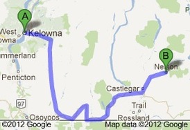
Kelowna to Nelson = 4-5hrs
Google maps directions
Take BC-33 S (signs for Rock Creek) out of Kelowna and at Rock Creek take a left onto Crowsnest Hwy/Rock Creek Bridge/BC-3 E (signs for Greenwood/Grand Forks) and continue to follow Crowsnest Hwy/BC-3 E past Grand Forks to Castlegar and take the BC-3A exit toward Nelson and stay on British Columbia 3A W
toward Nelson
Spokane to Nelson = 3hrs
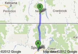
Google maps directions
Take US-2 E out of town and after Pend Orielle County Park turn left onto WA-211 N then merge left onto WA-20 W/State Route 20 W (signs for Ione Metaline Falls) and continue onto WA-31 N until Ione where you turn right onto S 2nd Ave and continue onto WA-31 N/Leigh Ave which you take to the border. After entering Canada (British Columbia) continue onto Nelson Nelway Hwy/BC-6 N until you hit a left onto Crowsnest Hwy/Nelson Nelway Hwy/BC-3 W/BC-6 N (signs for Salmo/Nelson/Castlegar) which you take to Salmo and then turn right onto Nelson Nelway Hwy/Railway Ave/BC-6 N (signs for Nelson/Salmo) and continue to follow Nelson Nelway Hwy/BC-6 N onto BC-3A W to Nelson
Take US-2 E out of town and after Pend Orielle County Park turn left onto WA-211 N then merge left onto WA-20 W/State Route 20 W (signs for Ione Metaline Falls) and continue onto WA-31 N until Ione where you turn right onto S 2nd Ave and continue onto WA-31 N/Leigh Ave which you take to the border. After entering Canada (British Columbia) continue onto Nelson Nelway Hwy/BC-6 N until you hit a left onto Crowsnest Hwy/Nelson Nelway Hwy/BC-3 W/BC-6 N (signs for Salmo/Nelson/Castlegar) which you take to Salmo and then turn right onto Nelson Nelway Hwy/Railway Ave/BC-6 N (signs for Nelson/Salmo) and continue to follow Nelson Nelway Hwy/BC-6 N onto BC-3A W to Nelson
